

At a glance
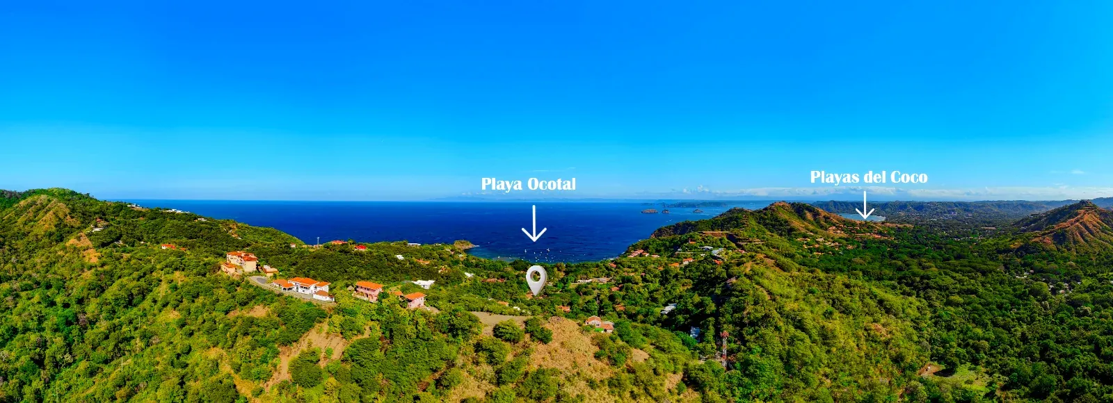
Playa Ocotal is a pocket cove on the Gulf of Papagayo, just southwest of Playas del Coco. It is small, framed by rocky points and green hills, and known for calm water, dark volcanic sand, and some of the best shore snorkeling on this stretch of coast.
Where it is
Ocotal is one of the villages of the Sardinal district, in the Carrillo canton of Guanacaste, Costa Rica's dry northwest. The beach sits in an inlet bounded by hills, which is exactly why the water stays gentle: the Costa Rican Tourism Institute (ICT) describes it as an inlet with grayish sand and low waves, good for swimming, diving and sportfishing.
The cove is roughly half a kilometer long, with high bluffs behind it, a rocky point at each end and a small island off the southern point. Look up from the sand and the ridges around the bay give wide views over the Gulf of Papagayo.
The neighbors
- Playas del Coco, a few minutes northeast: the town, with restaurants, shops, dive shops and a long, calm bay of nearly 3 km.
- Playa Danta, nearby: light gray sand, soft waves and views of the Pitahayas and Santa Catalina islands.
- Playa Gringo, a tiny sandy bay next door that snorkelers reach around the point from Ocotal.
A short history
The name
In Spanish, an ocotal is a stand of ocote pines; ocote comes from the Nahuatl word ocotl, a resinous pine prized for kindling. The name turns up in several places across Central America. We have not found a record of how this particular cove came by it, so treat that part as a pleasant mystery.
Guanacaste joins Costa Rica
The whole region has its own story. The Partido de Nicoya, today's Guanacaste, chose to join Costa Rica on 25 July 1824, a decision the Central American Federation approved that December. Every 25 July the province celebrates the Anexión del Partido de Nicoya with music, folk dance and the sabanero cowboy culture Guanacaste is known for.
A fishing cove that found the reef
Ocotal has always worked the water. Local fishing boats and sportfishing and dive boats still moor in the bay. Diving arrived early on this coast: the first professional beach-based dive operation in Playas del Coco opened in 1974, and the dive shop at Ocotal's beach resort became one of the longest running in the area, already running trips to the Catalina and Bat Islands by the mid 1990s. A beachfront bar and grill has been serving the cove since 1985.
Vista Ocotal
Vista Ocotal grew in phases around a community pool and rancho, under old shade trees, a short walk from the cove. Phase III, the final collection of twenty homes, completes it.
Blue Flag, explained
Costa Rica's Programa Bandera Azul Ecológica (Ecological Blue Flag Program) was created in 1996 by executive decree. It is administered by the ICT together with the national water institute (AyA), the Ministry of Environment (MINAE), the Ministry of Health, the Ministry of Education, ICE and the Ministry of Agriculture. Beaches are one of about ten categories; communities, schools, protected areas and climate action projects can earn flags too.
What a beach has to do
- Clean, tested water. AyA's lab tests the sea water and the sanitary conditions, and that counts for half of the score.
- A cared for coastline. The other half is the ICT's review of coastal sanitary conditions and environmental education.
- Safety and services. Signs warning of rip currents, lifeguard coverage on weekends and in peak season, and showers and toilets.
- Waste. Separation and recycling of what the beach produces.
- A local committee. Every flag is run by a community committee, and beaches compete with each other in a healthy way to earn and keep it.
Stars on the flag. Beaches are graded from one to five stars, and extra colored stars recognize work such as pollution management or coastal safety and education. Results are announced every year. In 2024, 151 beaches earned the award; the 2025 results, announced in March 2026 for the program's 30th anniversary, recognized 143 beaches, 13 of them with five stars.
Ocotal's flag
The ICT's official Guanacaste tourist guide lists Playa Ocotal as a beach that has received the Ecological Blue Flag, and nearby Playa Matapalo, also in Sardinal, appears as a five star Blue Flag beach. Because flags are renewed annually, check the current year's list for Ocotal's latest status and star rating.
Not the same as the international Blue Flag
The name is shared, but the programs are separate. The international Blue Flag is run by the Foundation for Environmental Education (FEE) and started in France in 1985. Costa Rica's Bandera Azul Ecológica is the country's own national program, run by its government agencies since 1996.
Under the water
Ocotal's reef is volcanic rock rather than hard coral, and it is busy. The rocky points at either end of the cove are where the life concentrates, and at low tide the rocks expose tide pools with sea stars.
Snorkel tips and tricks
- Head for the west point. The rocky point on the west side of the cove is the best spot. The left side has shallow ridges and sometimes turtles; the right side usually has the better visibility and the schools of surgeonfish.
- Stay shallow and close to the rocks. The snorkel area is only about 5 m deep at most, so there is no need to go far out.
- Watch for boats. Fishing and dive boats moor in the bay. Keep to the rocks, wear a bright cap or tow a small float, and never swim across the moorings.
- Go early. Mornings tend to be calmer and clearer before the wind picks up. The sea can still turn rough, so look before you go in.
- Mind the season. From about December to March the Papagayo winds drive an upwelling of cold, plankton-rich water. It feeds the marine life but can cool the water and cut visibility, strongest around February.
- There is no lifeguard at the point. Snorkel with a buddy, and keep kids in the calm water near the sand.
- Leave no trace. Do not stand on, touch or take anything from the rocks. A rash guard is better for the reef than a lot of sunscreen.
- No gear? No problem. Kayaks and snorkel sets are usually for rent on the beach.
Living one block away changes everything. When the water is glassy at 7 a.m., you just go. That is the whole point of the walk.
Wildlife on land
Ocotal sits in Guanacaste's tropical dry forest, which goes gold and bare in the dry season and explodes green when the rains come.
- Howler monkeys. Troops live in the trees around the beach. You will hear their roar at dawn long before you see them.
- Birds of the dry forest. White-throated magpie-jays with their curled crests, turquoise-browed motmots, orange-fronted parakeets, yellow-naped parrots and elegant trogons.
- Over the bay. Brown pelicans skimming the swell and ospreys fishing from the points.
Know the manchineel. Manchineel trees grow on the beach here. Their small green apples and their sap are toxic: do not eat the fruit, touch the sap, or shelter under the tree in the rain.
Seasons and whales
| When | Weather | In the water |
|---|---|---|
| December to April | Dry season, almost no rain and about 9 hours of sun a day. April is the hottest month. | Papagayo winds and cooler upwelling (December to March). Northern humpback whales (December to March or April). Mantas around the Catalina Islands. |
| May and June | Transition: first rains, the dry forest turns green. | Bull shark season opens at the Bat Islands from mid May. |
| July to October | Green season, wettest in September and October, usually sunny mornings and afternoon showers. | Southern humpback whales (July to November, peaking August and September). Bull sharks at the Bat Islands, peaking June to October. |
| November | Transition back to dry. | The last southern humpbacks. |
Humpbacks from both hemispheres visit Costa Rica's Pacific, so this coast is one of the few places with two whale seasons a year. The Papagayo area and El Coco are named viewing areas.
Boat trips and diving
- Local dive sites. More than twenty sites sit 10 to 20 minutes from shore, including Monkey Head, Punta Gorda, Tortuga, Virador and Aquarium. Expect volcanic rock, big schools of fish and the odd surprise.
- The Catalina Islands. The classic trip for mantas and devil rays, best in the cooler dry season months.
- The Bat Islands (Islas Murciélago). About 30 miles offshore, 60 to 90 minutes by boat, famous for large bull sharks in season. For experienced divers.
- Sportfishing. Charters run straight out of the bay; good fishing grounds start about 45 minutes out. Sailfish are protected and regulated in Costa Rica, and catch and release is the norm.
- Sunset sails. Catamaran cruises leave from Playas del Coco and are back in time for dinner.
Beach rules and safety
- Every beach is public. Under Costa Rica's Maritime Terrestrial Zone Law (Ley 6043, 1977), the first 50 meters from the high tide line are a public zone with free passage for everyone.
- Parking. Visitors park on the street near the beach entrances, where an attendant in an orange vest watches cars for a tip. From Vista Ocotal you can skip all of it and walk.
- Take everything home. Blue Flag beaches are judged on cleanliness, so pack out what you bring in.
- Sun. The Guanacaste sun is strong year round. Shade, a hat and a rash guard go a long way.
- Water sense. The cove is generally calm, but waves pick up with wind and tide. Watch children at the water's edge and respect any posted warnings.
FAQ
How far is the beach from Vista Ocotal Phase III?
One block, on flat ground. It is a short, level stroll, easy with a stroller, a cooler or small kids.
Is the water calm enough for children?
The cove is protected and generally calm, which is why families love it. Waves can still pick up with the wind, and there is no lifeguard at the snorkel point, so always keep an eye on little swimmers.
Does Ocotal keep its Blue Flag every year?
Flags are awarded every year by the national program. The ICT lists Playa Ocotal as a Blue Flag beach; check the current year's results for its latest status and stars.
Is the water warm all year?
It is tropical water, but from about December to March the Papagayo upwelling can make it noticeably cooler, especially around February. A dive report from August recorded 27 to 28°C.
Where do you eat near the beach?
There is a beachfront bar and grill right on the sand, and Playas del Coco, five minutes away, has everything from sushi and Italian to Costa Rican sodas and fresh fish.
En resumen
Playa Ocotal es una pequeña ensenada en el Golfo de Papagayo, justo al suroeste de Playas del Coco. Rodeada de puntas rocosas y cerros verdes, es conocida por sus aguas tranquilas, su arena volcánica oscura y uno de los mejores puntos de snorkel desde la orilla en esta costa.
Dónde está
Ocotal es uno de los poblados del distrito de Sardinal, en el cantón de Carrillo, Guanacaste, el noroeste seco de Costa Rica. La playa está en una ensenada rodeada de cerros, y por eso el agua se mantiene tranquila: el Instituto Costarricense de Turismo (ICT) la describe como una ensenada de arenas grisáceas y oleaje bajo, apta para nadar, bucear y la pesca deportiva.
La ensenada mide aproximadamente medio kilómetro, con acantilados detrás, una punta rocosa en cada extremo y un islote frente a la punta sur. Desde los cerros alrededor de la bahía hay vistas amplias del Golfo de Papagayo.
Los vecinos
- Playas del Coco, a pocos minutos al noreste: el pueblo, con restaurantes, comercios, tiendas de buceo y una bahía tranquila de casi 3 km.
- Playa Danta, cercana: arena gris clara, olas suaves y vista a las islas Pitahayas y Santa Catalina.
- Playa Gringo, una pequeña bahía de arena vecina a la que se llega haciendo snorkel alrededor de la punta.
Un poco de historia
El nombre
Un ocotal es un bosque de pinos ocote; ocote viene del náhuatl ocotl, un pino resinoso muy apreciado para encender fuego. El nombre aparece en varios lugares de Centroamérica. No encontramos un registro de cómo esta ensenada recibió el suyo, así que esa parte queda como un lindo misterio.
Guanacaste se une a Costa Rica
El Partido de Nicoya, hoy Guanacaste, decidió unirse a Costa Rica el 25 de julio de 1824, decisión que la Federación Centroamericana aprobó en diciembre de ese año. Cada 25 de julio la provincia celebra la Anexión del Partido de Nicoya con música, baile folclórico y la cultura sabanera que distingue a Guanacaste.
Una caleta de pescadores que descubrió el arrecife
Ocotal siempre ha vivido del mar. Los botes de pesca local, de pesca deportiva y de buceo siguen fondeando en la bahía. El buceo llegó temprano: la primera operación profesional de buceo desde la playa en Playas del Coco abrió en 1974, y la tienda de buceo del hotel de playa de Ocotal fue de las más antiguas de la zona, con viajes a las islas Catalina y Murciélago desde mediados de los noventa. Un bar y restaurante frente al mar atiende la playa desde 1985.
Vista Ocotal
Vista Ocotal creció por etapas alrededor de una piscina y un rancho comunales, bajo árboles de sombra, a una corta caminata de la playa. La Etapa III, la colección final de veinte casas, la completa.
La Bandera Azul, explicada
El Programa Bandera Azul Ecológica de Costa Rica nació en 1996 por decreto ejecutivo. Lo administra el ICT junto con AyA, el MINAE, el Ministerio de Salud, el MEP, el ICE y el MAG. Las playas son una de cerca de diez categorías; comunidades, centros educativos, áreas protegidas y acciones de cambio climático también pueden ganar bandera.
Lo que una playa debe cumplir
- Agua limpia y analizada. El laboratorio de AyA analiza el agua de mar y las condiciones sanitarias, y eso vale la mitad de la nota.
- Una costa cuidada. La otra mitad es la evaluación del ICT sobre condiciones sanitarias costeras y educación ambiental.
- Seguridad y servicios. Rótulos de corrientes de resaca, salvavidas los fines de semana y en temporada alta, duchas y servicios sanitarios.
- Residuos. Separación y reciclaje de lo que genera la playa.
- Un comité local. Cada bandera la gestiona un comité comunal, con una sana competencia entre playas para ganarla y mantenerla.
Las estrellas. Las playas se califican de una a cinco estrellas, y hay estrellas de colores adicionales por trabajos como el manejo de la contaminación o la seguridad y educación costera. Los resultados se anuncian cada año. En 2024, 151 playas obtuvieron el galardón; los resultados de 2025, anunciados en marzo de 2026 en el 30 aniversario del programa, reconocieron 143 playas, 13 con cinco estrellas.
La bandera de Ocotal
La guía turística oficial del ICT para Guanacaste indica que Playa Ocotal ha recibido la Bandera Azul Ecológica, y la cercana Playa Matapalo, también en Sardinal, aparece con cinco estrellas. Como las banderas se renuevan cada año, consulte la lista del año en curso para ver el estado y las estrellas más recientes de Ocotal.
No es lo mismo que la Bandera Azul internacional
Comparten nombre, pero son programas distintos. La Bandera Azul internacional la gestiona la Fundación para la Educación Ambiental (FEE) y nació en Francia en 1985. La Bandera Azul Ecológica es el programa nacional de Costa Rica, dirigido por sus instituciones desde 1996.
Bajo el agua
El arrecife de Ocotal es de roca volcánica, no de coral duro, y tiene mucha vida. Las puntas rocosas a cada lado de la ensenada concentran la actividad, y con marea baja las rocas dejan pozas con estrellas de mar.
Consejos para hacer snorkel
- Vaya a la punta oeste. Es el mejor sitio. El lado izquierdo tiene crestas poco profundas y a veces tortugas; el derecho suele tener mejor visibilidad y los cardúmenes de cirujanos.
- Quédese cerca de las rocas. La zona de snorkel tiene como máximo unos 5 m de profundidad; no hace falta alejarse.
- Cuidado con los botes. Botes de pesca y buceo fondean en la bahía. Manténgase junto a las rocas, use una gorra llamativa o una boya pequeña, y nunca cruce entre los fondeos.
- Vaya temprano. Las mañanas suelen ser más tranquilas y claras antes de que suba el viento. El mar puede picarse, así que observe antes de entrar.
- Tome en cuenta la época. De diciembre a marzo, aproximadamente, los vientos Papagayos provocan un afloramiento de agua fría y rica en plancton. Alimenta la vida marina, pero puede enfriar el agua y bajar la visibilidad, sobre todo en febrero.
- No hay salvavidas en la punta. Haga snorkel acompañado y mantenga a los niños en el agua tranquila cerca de la arena.
- No deje rastro. No se pare, no toque ni se lleve nada de las rocas. Una camisa de licra es mejor para el arrecife que mucho bloqueador.
- ¿Sin equipo? Normalmente se alquilan kayaks y equipo de snorkel en la playa.
Vivir a una cuadra lo cambia todo. Cuando el mar amanece como un espejo a las 7 a.m., simplemente va. Para eso es la caminata.
Fauna en tierra
Ocotal está en el bosque tropical seco de Guanacaste, que se vuelve dorado en verano y estalla en verde cuando llegan las lluvias.
- Monos congo. Tropas viven en los árboles alrededor de la playa. Los oirá rugir al amanecer mucho antes de verlos.
- Aves del bosque seco. Urracas copetonas, momotos cejiceleste, pericos frentinaranja, loras de nuca amarilla y trogones elegantes.
- Sobre la bahía. Pelícanos pardos rozando las olas y águilas pescadoras pescando desde las puntas.
Conozca el manzanillo. En esta playa crecen árboles de manzanillo de playa. Sus frutos verdes y su savia son tóxicos: no coma la fruta, no toque la savia y no se resguarde bajo el árbol cuando llueve.
Épocas del año y ballenas
| Cuándo | Clima | En el agua |
|---|---|---|
| Diciembre a abril | Época seca, casi sin lluvia y unas 9 horas de sol al día. Abril es el mes más caliente. | Vientos Papagayos y afloramiento frío (diciembre a marzo). Ballenas jorobadas del norte (diciembre a marzo o abril). Mantarrayas en las islas Catalina. |
| Mayo y junio | Transición: primeras lluvias, el bosque reverdece. | Desde mediados de mayo empieza la temporada de tiburón toro en las islas Murciélago. |
| Julio a octubre | Época verde, más lluviosa en septiembre y octubre, con mañanas soleadas y aguaceros por la tarde. | Ballenas jorobadas del sur (julio a noviembre, con pico en agosto y septiembre). Tiburón toro en las Murciélago, con pico de junio a octubre. |
| Noviembre | Transición de vuelta a la época seca. | Las últimas jorobadas del sur. |
Las jorobadas de ambos hemisferios visitan el Pacífico costarricense, así que esta costa tiene dos temporadas de ballenas al año. Papagayo y El Coco son zonas de avistamiento reconocidas.
Paseos en bote y buceo
- Sitios de buceo locales. Más de veinte sitios a 10 o 20 minutos de la costa, como Cabeza de Mono, Punta Gorda, Tortuga, Virador y Acuario.
- Islas Catalina. El viaje clásico para ver mantarrayas, mejor en los meses frescos de la época seca.
- Islas Murciélago. A unas 30 millas, de 60 a 90 minutos en bote, famosas por los grandes tiburones toro en temporada. Para buzos con experiencia.
- Pesca deportiva. Los charters salen de la misma bahía; las buenas zonas de pesca empiezan a unos 45 minutos. El pez vela está protegido y regulado en Costa Rica, y la captura y liberación es la norma.
- Paseos al atardecer. Los catamaranes salen de Playas del Coco y regresan a tiempo para cenar.
Reglas de playa y seguridad
- Todas las playas son públicas. Según la Ley sobre la Zona Marítimo Terrestre (Ley 6043, 1977), los primeros 50 metros desde la pleamar son zona pública de libre tránsito.
- Parqueo. Los visitantes parquean en la calle cerca de las entradas, donde un cuidacarros con chaleco anaranjado vigila por una propina. Desde Vista Ocotal se olvida de todo eso y camina.
- Llévese todo de vuelta. Las playas con Bandera Azul se califican por su limpieza.
- Sol. El sol de Guanacaste es fuerte todo el año. Sombra, sombrero y camisa de licra.
- Prudencia en el agua. La ensenada suele estar tranquila, pero las olas suben con el viento y la marea. Vigile a los niños en la orilla y respete los avisos.
Preguntas frecuentes
¿Qué tan lejos está la playa de Vista Ocotal Etapa III?
A una cuadra, en terreno plano. Una caminata corta y a nivel, fácil con coche de bebé, hielera o niños pequeños.
¿El agua es tranquila para niños?
La ensenada es protegida y generalmente tranquila, por eso las familias la adoran. Aun así las olas pueden subir con el viento y no hay salvavidas en la punta de snorkel, así que siempre vigile a los pequeños.
¿Ocotal mantiene la Bandera Azul cada año?
Las banderas se otorgan cada año. El ICT reconoce a Playa Ocotal como playa con Bandera Azul; consulte los resultados del año en curso para ver su estado y estrellas.
¿El agua es cálida todo el año?
Es agua tropical, pero de diciembre a marzo el afloramiento de Papagayo puede enfriarla, sobre todo en febrero. Un reporte de buceo de agosto registró 27 a 28°C.
¿Dónde comer cerca de la playa?
Hay un bar y restaurante frente al mar, y Playas del Coco, a cinco minutos, tiene de todo, desde sushi e italiano hasta sodas y pescado fresco.
Live one block from all of this
Vista Ocotal Phase III: twenty new four bedroom homes on flat ground, a short walk from Playa Ocotal.
Sources
- ICT, Guanacaste North tourist guide (Playa Ocotal, Playa Danta, wildlife, whales): page 44, page 45, page 91, page 114
- ICT, Ecological Blue Flag Program: ict.go.cr
- Revista Summa, 2024 Blue Flag results: revistasumma.com
- News in America, 2025 results and 30th anniversary: newsinamerica.com
- El Observador, how beaches earn the flag: observador.cr
- Snorkeling Report, Playa Ocotal: snorkeling-report.com
- Two Weeks in Costa Rica, Playa Ocotal: twoweeksincostarica.com
- Undercurrent dive reports: 2006 Ocotal report, 1996 chapbook
- Bill Beard Costa Rica, dive history and sites: history, local sites, Bat Islands
- Revista de Biología Tropical, Papagayo upwelling: scielo.sa.cr
- Tico Times, humpback seasons: ticotimes.net
- Ley 6043, Maritime Terrestrial Zone Law: snitcr.go.cr
- Semanario Universidad, Annexation of the Partido de Nicoya: semanariouniversidad.com
- Worldly Adventurer, Guanacaste seasons: worldlyadventurer.com
- Wikipedia, Sardinal district and the international Blue Flag: Sardinal, Blue Flag award
Last updated October 2026. Conditions, seasons and awards change; check locally before you go.